About us

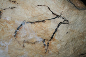
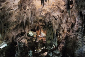
According to the recent archaeological discoveries of the Cueva de Nerja, the first settlers date from the Paleolithic to the Bronze Age, passing through the Epipaleolithic and Neolithic, with important human remains belonging to the Cro-Magnon.

The first historical indications about the Naricha or Narija farmhouse are from the period of Arab domination. It must have depended in some aspects on Vélez Málaga, like other places in the area, although that does not mean that it did not have its own entity. In fact, it had its own fortress that was located in the area today known as Pago del Castillo Alto, where this Arab population was located. Some remains of it can be seen in the angle formed by the Frigiliana path, at its crossroads with the Cantera neighborhood.

A tower was built on the coastline in the XNUMXth century, similar to those that exist elsewhere on the coast.

When in 1487 the Muslims of Vélez definitively surrendered to the Catholic king, they were followed in this action by the inhabitants of most of the Axarquía. In the Christian Chronicles this action is related and among the places mentioned Narija, our Nerja, is mentioned.

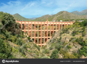
El Aguila aqueduct near Nerja. Malaga province, Andalusia, Spain

After the rebellion of the Moors, already in the XNUMXth century, a new fortress was erected in the place occupied by the coastal tower of the Balcón de Europa, which will later be demolished by the French in the XNUMXth century. Around it the population that had decided to abandon its original location was concentrated.

In the XNUMXth century the hermitage of Our Lady of Sorrows was built, a sanctuary dedicated to the Patron Saint of the town. This temple contains frescoes that cover its Granada-style dome.

In 1655 the population reached 400 residents and the streets Carmen, Iglesia, El Tajillo, Puerta del Mar, Plaza de Cavana, Calle del Corralón, today Gómez, have an urban body, and Granada Street begins to be traced.

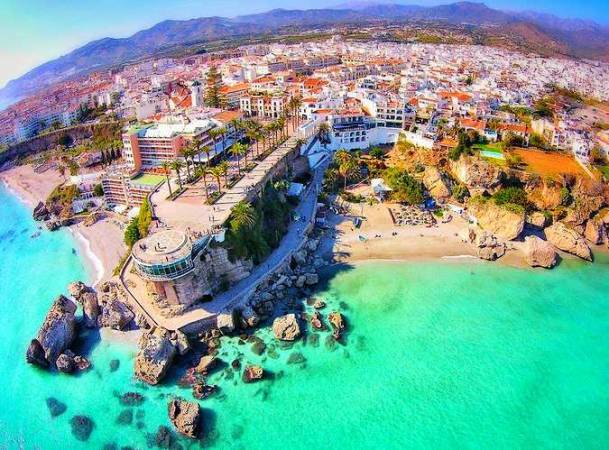
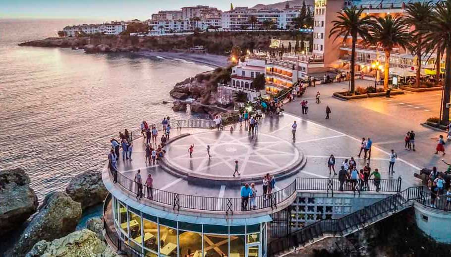
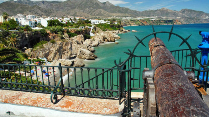
In 1660, when the mayor was D. Antonio de Villavicencio, the king ordered the construction of the Torre de los Guardas, today the Balcón de Europa. In 1697 the first phase of the parish of El Salvador was completed.

On December 25, 1884 there was a huge earthquake and on the occasion of these unpleasant events, His Majesty King Alfonso XII came to

 visit the affected area. After admiring the promenade of the “battery”, he officially called it the “Balcony of Europe”. It was also granted the treatment of "Excellency" to the City Council.

During the first two decades of the 1930th century, the road to Frigiliana was built and the Paseo Balcón de Europa was urbanized. In 1950, the Balcón de Europa and Calle de la Cruz and Granada streets were finally completed. In XNUMX the Municipal Market was inaugurated.

The discovery of the Cueva de Nerja in 1959 is a symbol of the new start and then comes the great tourist development that brings progress and prosperity and that changes the appearance of the social life of Nerja.

Beaches

    • Burriana

It is the beach with the highest tourist influx on the Nerja coast. Main access to the exit of Nerja in the direction 
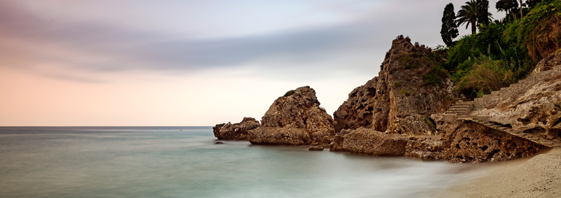
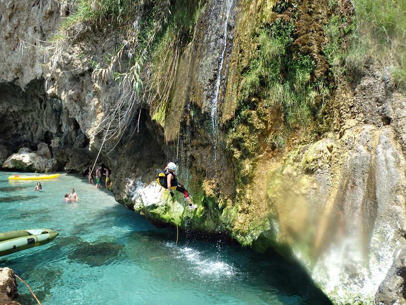
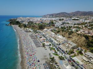
Almería on the N-340, and to the right, at the height of the “Verano Azul” urbanization. The fully equipped beach is often frequented by families. The environment is beautiful, because from it you can see mountains and cliffs. You can practice routes in kayaks, canoeing, snorkeling, scuba diving and play volleyball.
In 2004 it was one of the two Andalusian beaches distinguished with the Q for Tourist Quality in Beaches, a certificate that it currently maintains.

    • Maro

It is a sandy beach of considerable size, easily accessible and very popular in the summer.
To get there, we must take the same regional road as to access Playa de la Caleta until we reach a square with little parking capacity. From here we can go down to the beach, where there is a picnic area.

    • Cove of Maro

A sandy beach of medium size and sheltered under the Cliffs and the Vega de Maro. Its natural beauty gives it a certain wild charm.
It is accessed by entering through the crossing of the Cueva de Nerja a Maro, crossing it and going down a regional road that runs between crops and greenhouses.

    • Alberquillas

This beach is large and is linked to the Molino de Papel Beach by the remains of the Torre del Río de la Miel.
It is accessed by a detour to the right that cannot be clearly seen from the N-340 after about 200 meters from kilometer 299. It is a lane in good condition through which you can walk down to the beach itself. It is a pleasant place to spend a typical beach day.

    • Pine Coves

They are two sandy coves of medium proportions located between the Playa de las Alberquillas and the Torre del Pino. Although separated by detached rocks, it is possible to pass easily from one to another.
They are reached by a path that starts from the third of the abandoned curves of the old N-340 that is on the right after kilometer 299. The path descends steeply to the beach among the dry scrub.

    • Gutter

It is a large, popular beach with two picnic areas. There is a bus in summer every 10 minutes that goes down to the beach for 2 km.

    • great beach

The long and wide beach consists of two accesses that we can make by vehicle: to the right, at km 289,5 of the N-340 towards Almería, the route is short and within the same town, going down Calle Antonio Ferrándiz, and Arriving at “IES El Chaparil”, the old San José Factory, we turn right along a lane that, after crossing the Chíllar river, overlooks the beach. The most spectacular thing about the beach is its surroundings: the plain of Nerja . The rivers Chíllar to the east and Seco to the west will flow into it.

    • The Chucho

It is located between the mouth of the Chíllar River, which connects it with Playazo beach, and which is one of the possible accesses to it, and Torrecilla beach.

    • Torrecilla

Beach with a large number of people and a pedestrian promenade. Accesses: through El Chucho beach along the promontory where the Torrecilla tower ruins are located, from where the beach gets its name, by the existing descent at the end of c / Antonio Añejo, by Paseo de the Plaza de los Cangrejos and down the road to the beach, at the end of Avenida Castilla Pérez. Well equipped beach.
Since 2006 it has been distinguished with the Q for Tourist Quality in Beaches, a certificate that it currently maintains. Each year distinguished with the EU Blue Flag.

    • The living room

Small urban beach located on a cliff. Good services. Its access is through the Plaza de la Iglesia, located on the Balcón de Europa. It is only possible to reach it on foot. It is equipped with a telephone, wastebaskets.

    • The Caletilla

Small beach with a cliff and good services. It has two accesses: through the Hotel Balcón de Europa (private), located on the promenade from which it receives its name, and through the Calahonda beach.

    • Calahonda

Located under the Balcón de Europa, which we can access by going down the “boquete de Calahonda”, which is at the end of Puerta del Mar street. 

With great influx. From this beach you can see some picturesque cliffs.


    • Trickle

To get to this secluded cove we take the path that is accessed from the Balcón de Europa.

    • Carabeo

Small beach with access through Calle Carabeo through a stepped downhill that exists at the end of the street. With great influx.

    • carabeillo

Small cove we access it by going down from the “Mirador del Bendito”, located at the end of Carabeo street, or by Burriana Beach. We will always do the walking tour.

Cuevas de Nerja

It was on January 12, 1959 when Francisco Navas Montesinos, Manuel and Miguel Muñoz Zorrilla, José Luis Barbero de Miguel and José Torres Cárdenas, descended the place known as “La Mina” and found the current room of the Cascada or the Ballet of the impressive Cueva de Nerja.

The Nerja Cave, called “Natural Cathedral of the Costa del Sol”, is located 750 meters from the coast on a hillock, about 200 meters above sea level and on the face of the Sierra de Almijara. The cavity open to the public has an area of about 140.000 square meters, and its maximum length is 700 meters.

But the most attractive thing is the large column located in the Cataclysm Room with a height of 60 meters and a diameter of 18 meters. It is located 5 km from the town center and 1 km from the annex of Maro. At present, works are being carried out for the opening of new galleries.

The access to the Cave is verified by a staircase until reaching a room, 14 meters wide and 3 meters high; its soil has a huge archaeological fill. This first room and the next are linked by a winding corridor, which descends until it ends in the second room of relative width, since it is about 20 meters long, 10 wide and 5 high. This height is the Bethlehem Room.

The Bethlehem Room communicates on its left with another room, that of the Elephant's Tusk. From here you descend until you come to a balcony that, on your right, is called the Cascada or Ballet Room, where the annual Festival takes place.

Through a wide passageway crossed by a tall column of more than eight meters in circumference, you pass the Room of the Ghosts and to the left there are several steps under a set of rocks that lead to the Room of the Cataclysm, the largest in the Cave. In the center emerges an immense column 45 meters high, 20 in diameter and 64 meters in perimeter, included in the Guinness Book as the largest column in the world.

At the back of this room, you can see a red light that is the only variable communication with the high or new galleries, in which there are several rooms equivalent to seven times the size of the rooms that can be visited. In the rest of the rooms there are cave paintings and they are the following: Room of the Columns of Hercules, Room of the Mountain, Room of the Arena, Room of the Hispanic Goat and Room of the Immensity.

Inside there are some showcases where archaeological pieces of great value are exhibited. Furthermore, cave paintings have been found which, according to Professor Sanchidrián Torti, are found in the "solutrean parietal sanctuary" with two types of inconography, "beast" (equidae, cervids and caprids) and "abstract" (curvilinear motifs); “Magdalenian mono-themed chapel” located in the upper galleries and where the “Sanctuary of the Dolphins” appears and post-Palaeolithic art with the anthropomorphic figures of the Sala de la Torca, which appear in a dance attitude.

The human remains that appear correspond to the Cro-Magnon man and Solutrean levels also appear, judging by the remains found.

La Cueva de Nerja is not only famous for its archaeological sites and its stone formation, but also for its International Festival of Music and Dance, which is repeated every year during the month of July.

Maro

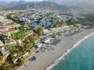
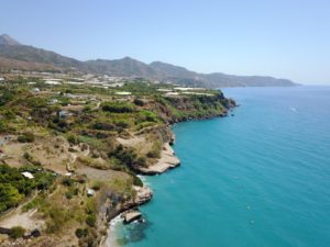
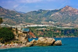
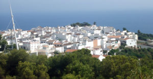
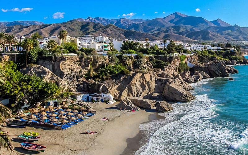
Maro is a beautiful white town that is located on the cliffs of the bay of Nerja, between the Caleta and the Barranco de Maro; between the Balcón de Europa and Cerro-Gordo.
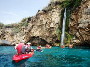
According to the historians Simonet and Guillén de Robles, they place the current Maro in the Roman Detunta, between Sexi (Almuñécar) and Claviclum (Torrox), next to the Roman road from Cástulo to Malaca by Orgi. At that time it was a small village or factory dedicated to commerce.

During the Muslim period, it was a small farmhouse dedicated to agriculture and derived industry, such as silk and cane honey.

It takes a great relief after the taking of Naricha by the Catholic Monarchs in 1487 and the distribution of 1490 in favor of the Jew Maymón Leví, whose inheritances were pointed out by Juan Cortina and Diego de Vargas, in Nerja and Maro.

In its plain of Sanguino the best tropical fruits of the area are grown and, according to research although without historical rigor, its name is due to a small battle that took place, in the reign of Felipe II, between Hernando el Darra and Captain Antonio of Moon. This event took place in 1570 and must have developed in the stream of this name, a natural outlet from the Sierra Almijara towards the cove of Maro.

In the middle of the seventeenth century Maro was Señorío, being its most notable gentleman D. Lucas Navío de la Peña.

There is also another historical fact, arrived by oral transmission, which indicates the visit of Cardinal Cisneros to this area and that he spent the night in a fortified tower, which existed where today is the "Casa Grande" and the ruins of the second mill or sugar mill. built in Nerja at the beginning of the seventeenth century.

In 1668 it had its first parish priest, the priest Francisco Ponce. Prior to this date, Our Lady of Wonders was enthroned as the patron saint of the town.

Doña Rosa María de Vera paid for, for a decade in the mid-8th century, mass and procession of Our Lady of Wonders, on September XNUMXth.

Maro had one of its most prosperous stages in the first third of the XNUMXth century with the export of extra-early fruits and today, while still being a people that lives from agriculture, it is opening up to tourism.

Tourist Office

M-F: 10.00-14.00 and 18.30-21.45
SD: 10.00-13.45
C / Carmen 1, 29780 Nerja, Malaga

www.turismo.nerja.es
tourism@nerja.es
(0034) 952 521 531

Call us
TE LLAMAMOS SIN COMPROMISO
Nuestro lema ha sido siempre prestar un servicio profesional y personalizado, porque la satisfacción de nuestros clientes es nuestra mejor propaganda. Con mucho gusto le ayudaremos para encontrar la propiedad ideal para Usted, sea que está buscando un chalet, un apartamento y una casa en el pueblo. Tenemos acceso a una gran variedad de propiedades en venta y en alquiler en toda España.
We use cookies to ensure you get the best experience on our website Accept cookies More Info